• Home
  • Games
    Action-adventure Simulation Business Role Playing Sports Competition Casual Intelligence Card Strategy Music Rhythm Text Puzzle Flying Shooting Love Development
  • Apps
    Business Office Newsletter Social Life Entertainment Online Shopping Practical Tools Travel Financial Management Educational Learning Information Reading Sports and Health
  • Articles

English 中文(简体) 中文(繁体) 한국어 日本語 Português Español Русский العربية Indonesia Deutsch Français ภาษาไทย
Home Apps Practical Tools Satellite Weather Radar India
Satellite Weather Radar India

Satellite Weather Radar India

1
2
3
4
5
Download
  • Version 4.6
  • Category Practical Tools
  • Package Name com.radar.rahul.indiaweatherradar
  • Update Time March 19, 2025
  • Size 7.77MB
About this app

India weather radar and satellite images

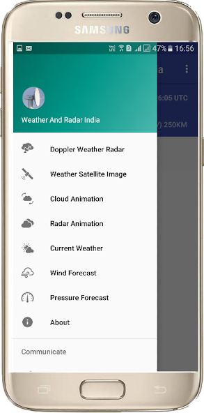
Key Features of Weather & Radar India app:

• This is best Live Weather Report App of India.

• India live Doppler weather radar Images.

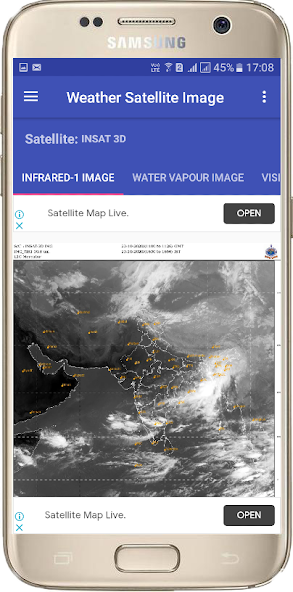
• Indian Sector Latest weather Satellite Images.

• Every 10 minutes radar image updated.

• 24 India city's Doppler Weather Radar Images.

• Change your desire city and see the clouds position.

• You will get accurate Weather Forecast.

• Best satellite weather map live india.

• Live insat satellite image india.

• Best weather India App.

• Insat 3D, Insat 3DR and Meteosat-8 Satellite Images.

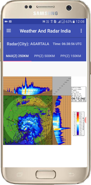
Doppler Weather Radar Image Features:

• MAX(Z) => Maximum Display(Z) -This radar image gives the clouds position with cloud height within 250 KM range.

• PPZ500 => Plan Position Indicator(Z) -This radar image gives the clouds position within 500 KM range.

• PPZ150 => Plan Position Indicator(Z) -This radar image gives the clouds position within 150 KM range.

• PPV => Plan Position Indicator(Radial Velocity) -This radar image gives the clouds radial velocity within 250 KM range. The radial velocity towards radar site is taken as negative value (-ve) and away from radar site is taken as positive value (+ve).

• VVP2=> Volume Velocity Processing 2-This radar image gives the direction and radial speed of winds in different standard layer/height from surface.

• SRI – Surface Rainfall Intensity -This Image is an image of the rainfall intensity in a user selected surface layer within 100 KM range.

• PAC - Precipitation Accumulation -This Image shows the total rainfall amount in (mm) within 24 Hours. 250 KM range.

This App gives you the easy access and quick view of clouds over your city from Doppler weather radar images and satellite images published by India Meteorological Department.

Download(7.77MB)
Users also viewed
  • MY3Macau

    MY3Macau

    2.3.36 July 6, 2025
  • AppLock | Privacy Protector

    AppLock | Privacy Protector

    3.06 July 6, 2025
  • Zombie Pop LW Free

    Zombie Pop LW Free

    1.2.2 July 6, 2025
  • Cashier Toy Videos

    Cashier Toy Videos

    2.0 July 6, 2025
  • Binary Decimal Converter

    Binary Decimal Converter

    3.1 July 6, 2025
  • Rappers and Blunts Wallpapers!

    Rappers and Blunts Wallpapers!

    2.1 July 6, 2025
  • magnifying glass with light

    magnifying glass with light

    24.0 July 6, 2025
  • CartoonPlay LINE LauncherTheme

    CartoonPlay LINE LauncherTheme

    4.1 July 6, 2025
  • Freemeteo

    Freemeteo

    2.0.25 July 6, 2025
  • Pug Dog Wallpapers

    Pug Dog Wallpapers

    4.0.1 July 6, 2025
  • Modern Home Design

    Modern Home Design

    5 July 5, 2025
  • DTSO

    DTSO

    5.0 July 5, 2025
  • Pic Mirror Effect

    Pic Mirror Effect

    1.2.4 July 5, 2025
  • Time Us!

    Time Us!

    1.1.4 July 5, 2025
  • ChatPro

    ChatPro

    1.0.55 July 5, 2025
About Privacy Policy Terms of Service Cooking Policy

© Copyright 2017-2025 downzq.com