• Home
  • Games
    Action-adventure Simulation Business Role Playing Sports Competition Casual Intelligence Card Strategy Music Rhythm Text Puzzle Flying Shooting Love Development
  • Apps
    Business Office Newsletter Social Life Entertainment Online Shopping Practical Tools Travel Financial Management Educational Learning Information Reading Sports and Health
  • Articles

English 中文(简体) 中文(繁体) 한국어 日本語 Português Español Русский العربية Indonesia Deutsch Français ภาษาไทย
Home Apps Travel Offline Location Tracker
Offline Location Tracker

Offline Location Tracker

1
2
3
4
5
Download
  • Version 3.3 - 27.Nov.20
  • Category Travel
  • Package Name com.arn.loc
  • Update Time May 13, 2025
  • Size 2.16MB
About this app

Battery efficient location tracker & geotagger. Doesn't use GPS, WiFi, BT or net

Features:

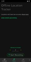
• Offline location tracking

• Sharing of your location. Use SMS if offline

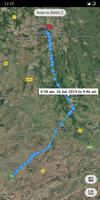
• Detailed view of recorded journeys on map

• Export routes as KML

• Automatic batch geotagging of photos

• Backup and restore of saved data to device storage

This app uses information from mobile towers around you to track your location, instead of using power hungry GPS, WiFi, Bluetooth or an internet connection. It works offline.

This app is ideal for long distance road travellers who do not have data packs or want to save battery during the trip by turning off data and not using GPS, without losing the ability to track location or to store location in photos.

Note:

⦿ The range of a mobile tower can be in kilometers. If you are looking for high accuracy or only go on short journeys, this app is not for you and you may not install it.

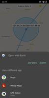
⦿ You need internet to load the map or to resolve the recorded mobile tower info into geo coordinates. You can do this anytime later, maybe after you are back home.

Geotagging pics

To geotag pics, just put this app in recording mode while you click photos. When you get home, you just need to resolve the locations recorded and start the geotagger. The geotagger automatically selects locations from your records, based on the time when the picture was taken.

I added this because I don't want GPS-like accuracy in photos, but just want to know whether it was taken near a monument or at the railway station area. And waiting for GPS to fix before photographing life's short moments is not always possible. Not to mention additional data expenses if you use assisted GPS.

What's New in the Latest Version 3.3 - 27.Nov.20

Last updated on Nov 28, 2020 Bug fixes
Download(2.16MB)
Users also viewed
  • Pusula

    Pusula

    1.0 October 20, 2025
  • QuickGo

    QuickGo

    0.4 October 19, 2025
  • GT NextBus - ICS Edition

    GT NextBus - ICS Edition

    2.0.1 October 19, 2025
  • Offline GPS Tracker

    Offline GPS Tracker

    1.0.0 October 19, 2025
  • WikiRoutes. Public transport

    WikiRoutes. Public transport

    1.9 October 19, 2025
  • Carologia

    Carologia

    1.0 October 19, 2025
  • WWL Mardi Gras Parade Tracker

    WWL Mardi Gras Parade Tracker

    10.0.13 October 18, 2025
  • Cagliari Orari CTM

    Cagliari Orari CTM

    1.8.4 October 18, 2025
  • Biznes Taxi Andijon

    Biznes Taxi Andijon

    3.15.20 October 18, 2025
  • CarWebGuru

    CarWebGuru

    3.6.0 R5 October 18, 2025
  • Amsterdam

    Amsterdam

    4.6.0 October 18, 2025
  • Waze

    Waze

    5.0.0.3 October 17, 2025
  • Mico

    Mico

    2.2.8 October 17, 2025
  • Live Traffic (Malaysia)

    Live Traffic (Malaysia)

    21.3.0 October 17, 2025
  • RouteShout

    RouteShout

    1.0 October 17, 2025
About Privacy Policy Terms of Service Cooking Policy

© Copyright 2017-2025 downzq.com