• Home
  • Games
    Action-adventure Simulation Business Role Playing Sports Competition Casual Intelligence Card Strategy Music Rhythm Text Puzzle Flying Shooting Love Development
  • Apps
    Business Office Newsletter Social Life Entertainment Online Shopping Practical Tools Travel Financial Management Educational Learning Information Reading Sports and Health
  • Articles

English 中文(简体) 中文(繁体) 한국어 日本語 Português Español Русский العربية Indonesia Deutsch Français ภาษาไทย
Home Apps Travel Miami Trolley
Miami Trolley

Miami Trolley

1
2
3
4
5
Download
  • Version 1.0
  • Category Travel
  • Package Name com.cityofmiami.miamitrolley
  • Update Time September 27, 2025
  • Size 19.13MB
About this app

Find Miami Trolley routes and stops near you.

Miami Trolley tracker is the ultimate tool to find your way around the City of Miami. Designed for residents and visitors alike, this app is a must-have. Find Miami Trolley routes and stops near you, and make your next trip around town a breeze. Now you have more time to enjoy all Miami has to offer—eclectic restaurants and cafés, the hottest cultural and sporting events, the finest shopping destinations, and so much more!

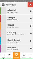
The Miami Trolley is a free, fun and convenient way to explore some of the most unique and captivating neighborhoods in Miami. This signature public transportation service runs predefined routes through staple Miami urban areas such as Allapattah, Downtown, Brickell, Midtown and the Design District, the Health District, and Overtown, providing quick and convenient block-to-block trips.

Predetermined routes: Allapattah, Biscayne, Brickell, Coral Way, Health District, Overtown, and Stadium. Also, the Miami Trolley system seamlessly connects to several Miami-Dade Transit Metrobus, Metromover, and Metrorail stations, and to the neighboring City’s Trolley Route along Ponce de Leon Boulevard. All Trolleys are accessible to riders using wheelchairs and are ADA Compliant.

Features

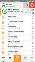
- Check the distance of the Trolley from any stop; app refreshes every 10 seconds

- App will automatically map out the closest route and stop based on your current location

- Check out all existing routes and service times

- Turn off routes you don’t want displayed and choose your ‘favorite’ ones for quicker access

Download(19.13MB)
Users also viewed
  • Trova Banca e Bancomat

    Trova Banca e Bancomat

    1.1 January 13, 2026
  • Belfast Map and Walks

    Belfast Map and Walks

    51 January 13, 2026
  • HobDrive OBD2 diag, trip

    HobDrive OBD2 diag, trip

    1.7.16 January 13, 2026
  • Walking Navigation AR!

    Walking Navigation AR!

    7.3 January 13, 2026
  • APSRTC City Bus Live Track

    APSRTC City Bus Live Track

    8.1.7 January 12, 2026
  • Park-abled

    Park-abled

    3.04 January 12, 2026
  • PomerodeBus

    PomerodeBus

    1.6 January 11, 2026
  • Easy Fuel Log

    Easy Fuel Log

    0.55 January 11, 2026
  • Radio Taxi 114 - Cliente

    Radio Taxi 114 - Cliente

    1.42 January 11, 2026
  • MAGNUM GSM car alarm system

    MAGNUM GSM car alarm system

    3.5.2 January 11, 2026
  • St Petersburg.Traveler's guide

    St Petersburg.Traveler's guide

    1.0 January 10, 2026
  • Avto Video Registrator AVR

    Avto Video Registrator AVR

    6.1.112 January 10, 2026
  • PINCode India

    PINCode India

    3.0 January 10, 2026
  • Elba Spiagge versione demo

    Elba Spiagge versione demo

    1.0 January 9, 2026
  • Selea CPS Monitor

    Selea CPS Monitor

    4.3.0.0 January 9, 2026
About Privacy Policy Terms of Service Cooking Policy

© Copyright 2017-2026 downzq.com