
Go Track is mobile client for OpenGTS open source project.
Go Track is mobile client for OpenGTS open source project. It is designed to view last GPS position of the devices configured in OpenGTS and also view the trail of the device in map.
Go Track app is designed to show the standard icons comes with default OpenGTS server. Customer who have customized PushPin Icons in OpenGTS server, will not be view their customized PushPin Icons in Go Track app. The customized icons will be shown as black icons.
We have developed www.GoTracky.com for customers to easily rebrand GoTrack app based on Company Name, Logo and Color Theme. Also, the rebranded app will be able to integrate customized PushPin Icons in customer's OpenGTS server.
OpenGTS™ ("Open GPS Tracking System") is the first available open source project designed specifically to provide web-based GPS tracking services for a "fleet" of vehicles (http://www.opengts.org).
This FREE version is ad supported and limitation of viewing 3 vehicles. Free rebranded app via www.GoTracky.com shows all devices.
Features:
- View vheicles configured in OpenGTS.
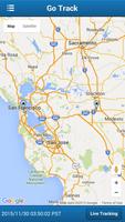
- View most recent position of the vehicle in Map.
- View all vehicles and last position in Map.
- Search for vehicle track based on date.
- Manual and auto update of vehicle position and track (update every 1 minute)
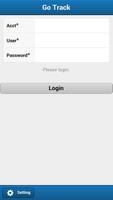
Configuration:
- In settings page, configure the OpenGTS server URL.
http://www.mydomain.com/track/
- Set track.enableAuthenticationService to true in private.xml.
Version 4.4
- Changed Google Map to Openstreet Map
- Issues fixed
Version 4.3
New Features and Issued fixed:
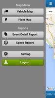
- Two new reports added - Event Detail and Speed Report
- Refresh device list when changing account, i.e. logout and login with another account.
- Option to search for Device in Device List
- In Settings, OpenGTS URL will be defaulted to http://, to facilitate faster entry.
Version 4.0
1. Fixes to work with latest version of OpenGTS.
New Features:
1. Sliding Menu for easy navigation.
2. Vehicle Latest location information such as Address, Speed, Odometer and Status (such as Start, InMotion or stop) is shown in Vehicle Map.
3. Locate feature in Vehicle Map to display the users current location.
4. When a vehicle is lost, Vehicle Latest location information, Live Tracking and Locate feature in Vehicle Map is useful to track and follow the vehicle based on user's current location.
Reports Enhancements:
1. Report display is optimized for easy viewing of report details.
2. Event Detail Report show summary such as Total distance travelled (based on Odometer), from and to address.
3. Event Detail Report information can be viewed on Map.
Version 3.2
Issues Fixed in this version:
- App not working in Android 4.x
- Apps crashes when physically turning the mobile from portrait to landscape (or the other way around)
- Search result will remove the existing track on the map.
- Marker bubble: clicking on new bubble will remove the old bubble. Also, the bubble will automatically removed after 30 seconds.
Version 3.1
Issues Fixed:
- Data persistence issue (entering OpenGTS URL every time to run the apps)
New Features:
- In vehicle list, added last event address and date time.
- In Group Map, auto zoom to show all the vehicles.
- In Settings following options will be added:
- Limit no of data points in Vehicle Map.
- Show/hide the markers in Vehicle Map.
- Show/hide the route arrow in Vehicle Map.
Version 3.0
Fixed the problem with Login Failure issue.
Version 2.0
Removed the Camera permission.
 Download