• Home
  • Games
    Action-adventure Simulation Business Role Playing Sports Competition Casual Intelligence Card Strategy Music Rhythm Text Puzzle Flying Shooting Love Development
  • Apps
    Business Office Newsletter Social Life Entertainment Online Shopping Practical Tools Travel Financial Management Educational Learning Information Reading Sports and Health
  • Articles

English 中文(简体) 中文(繁体) 한국어 日本語 Português Español Русский العربية Indonesia Deutsch Français ภาษาไทย
Home Apps Travel GNSS Status
GNSS Status

GNSS Status

1
2
3
4
5
Download
  • Version 0.9.16d
  • Category Travel
  • Package Name at.harnisch.android.gnss
  • Update Time July 6, 2025
  • Size 50MB
About this app

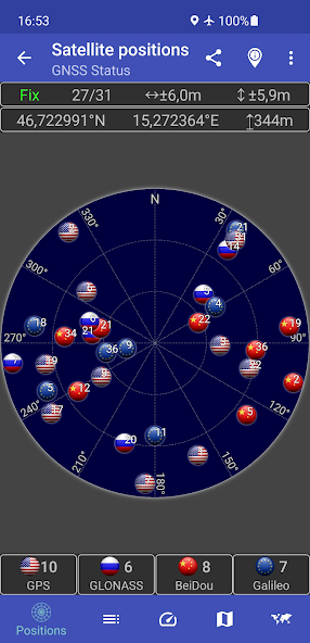
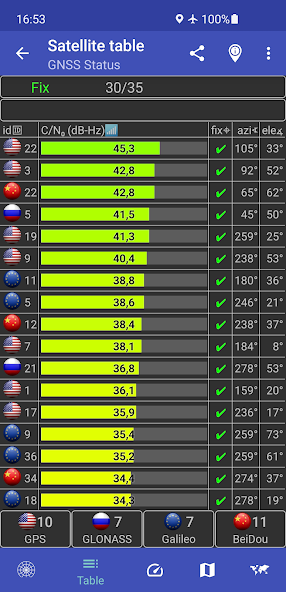
Get GPS status and status of GLONASS, Galileo and BeiDou satellites

This app is a tool for displaying the GPS status and the status of other GNSS (global navigation satellite systems). It provides all information about all GNSS supported by your device (GPS, GLONASS, Galileo, BeiDou, ...).

Your location can be shown as latitude/longitude, UTM (Universal Transverse Mercator), MGRS (Military Grid Reference System), OLC (Open Location Code / Plus Code), Mercator, QTH/Maidenhead, Geohash or CH1903+.

Via the "Share" functionality you can share your location to tell someone exactly where you are, this can be very helpful not only in emergencies. Location can be shared as latitude/longitude or as link to all major map services.

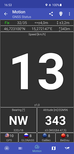
Furthermore, functions such as a GPS speedometer, a "Find my car" and a "My Places" functionality are integrated. This makes it possible to calculate and display routes to the location of the car or to other previously saved locations and to be able to navigate there.

The app supports the display of any GPX files with various map services.

New: Record your tracks while hiking, running or cycling, or import GPX files to find the right path while hiking, running or cycling. Export your captured tracks as GPX files. While hiking, running or cycling, you can share your previous route and your current location as a GPX file via email or social networks at any time. The finished GPX file can also be shared via email and social networks. At the recipient of the shared GPX file, clicking on this file opens and displays our app.

Choose between several map providers for the map displays, we also support offline maps!

What's New in the Latest Version 0.9.16d

Last updated on Nov 4, 2024 ★ Improved maps provider 'Mapsforge (offline)'
- Rotation of map
- Themes
? Minor fixes
Download(50MB)
Users also viewed
  • Roadside Helper

    Roadside Helper

    1.3 October 30, 2025
  • Wallpaper Qatar

    Wallpaper Qatar

    1.3 October 30, 2025
  • Bus Routes of Bangalore BMTC

    Bus Routes of Bangalore BMTC

    2.0 October 30, 2025
  • ATC mobile La Spezia

    ATC mobile La Spezia

    2.6.220 October 29, 2025
  • My carcam

    My carcam

    1.0.4 October 29, 2025
  • TuTaxi Da Confianza

    TuTaxi Da Confianza

    1.2 October 29, 2025
  • Remisses Alas

    Remisses Alas

    1.9.3 October 28, 2025
  • Ease Parking Fee

    Ease Parking Fee

    1.0.1 October 28, 2025
  • Tenerife Guide

    Tenerife Guide

    1.0.6 October 28, 2025
  • been

    been

    1.0 October 28, 2025
  • AutoDrive

    AutoDrive

    5.0.3 October 27, 2025
  • Trafik Rehberi

    Trafik Rehberi

    5.0.3 October 27, 2025
  • Kapten Driver

    Kapten Driver

    1.62.1 October 27, 2025
  • PrestoPark

    PrestoPark

    4.3.0a-PP October 26, 2025
  • Outdooractive

    Outdooractive

    1.9.13 October 26, 2025
About Privacy Policy Terms of Service Cooking Policy

© Copyright 2017-2025 downzq.com