• Home
  • Games
    Action-adventure Simulation Business Role Playing Sports Competition Casual Intelligence Card Strategy Music Rhythm Text Puzzle Flying Shooting Love Development
  • Apps
    Business Office Newsletter Social Life Entertainment Online Shopping Practical Tools Travel Financial Management Educational Learning Information Reading Sports and Health
  • Articles

English 中文(简体) 中文(繁体) 한국어 日本語 Português Español Русский العربية Indonesia Deutsch Français ภาษาไทย
Home Apps Practical Tools Flood Zone Map
Flood Zone Map

Flood Zone Map

1
2
3
4
5
Download
  • Version 1.12.1
  • Category Practical Tools
  • Package Name com.rmtheis.flood
  • Update Time June 15, 2025
  • Size 7.02MB
About this app

Generates a printable flood risk map for locations in the USA

This app displays a printable map that shows the flood-prone areas near a given street address in the United States. Identify flood zones to watch out for after a rainstorm, tropical storm, or hurricane.

To use:

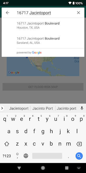
• Type your street address in the "Address" field

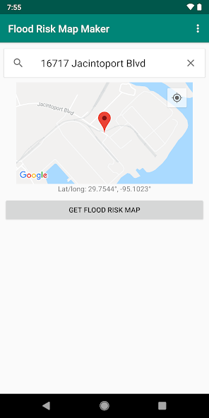
• Tap the "Get Flood Risk Map" button

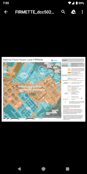
Maps generated by this app are not interactive maps, but maps—usually PDFs—that are suitable for emailing and printing out on paper.

Depending on the availability of the flood study data in your area, this app will generate one of the following results:

• Areas with modern digital FEMA flood study data: A printable PDF showing about 400 acres or about 0.6 sq. mi.

• Areas with old FEMA flood study data: A zip file with a scanned image of an old (often 1980s) printed map

• Remote areas where a FEMA flood study has not been conducted: No map available

Ideal for:

★ Homeowners and home buyers

★ Real estate agents

★ Farmers

★ Insurance professionals

★ Businesspeople

★ Anyone doing a risk assessment or asking "Am I in a flood zone?"

Ad-supported. If you like the app, please consider upgrading to remove the ads and support future development.

HAVING TROUBLE?

This app requires having a PDF viewer app—such as the Adobe Acrobat Reader app—installed on your phone. Many phones have one installed already. You also need to have a web browser app installed, like Google Chrome or Firefox.

If the FEMA study data in your location is old, you'll need to have an app for opening zip files (such as Winzip) and an app for opening TIFF files (such as Multi-TIFF Viewer Free) so you can open the scanned maps that are used for those locations.

Hurricane Irma aftermath photo by Wade Austin Ellis

Download(7.02MB)
Users also viewed
  • ARChon Packager

    ARChon Packager

    0.9.6 July 2, 2025
  • 14 days Transparent Weather

    14 days Transparent Weather

    2.1.0 July 1, 2025
  • Cardo SmartSet

    Cardo SmartSet

    3.5 July 1, 2025
  • KCBD First Alert Weather

    KCBD First Alert Weather

    5.15.409 July 1, 2025
  • Call Receive on Air

    Call Receive on Air

    1.3 July 1, 2025
  • Earthquake Zone

    Earthquake Zone

    3.0.6 July 1, 2025
  • Garden Art

    Garden Art

    5.1.0 July 1, 2025
  • Comic

    Comic

    1.1.7 July 1, 2025
  • KSWEB

    KSWEB

    3.988 July 1, 2025
  • IIDX Viewer

    IIDX Viewer

    4.1.5 July 1, 2025
  • Download All Files

    Download All Files

    3.3.0 July 1, 2025
  • gAppsLauncher

    gAppsLauncher

    2.1 July 1, 2025
  • Whats Up Finder old

    Whats Up Finder old

    1.0 July 1, 2025
  • Dalgomi(knitting)Dodol Theme

    Dalgomi(knitting)Dodol Theme

    4.1 July 1, 2025
  • Alerte Meteo Romania

    Alerte Meteo Romania

    2.1.7 July 1, 2025
About Privacy Policy Terms of Service Cooking Policy

© Copyright 2017-2025 downzq.com