• Home
  • Games
    Action-adventure Simulation Business Role Playing Sports Competition Casual Intelligence Card Strategy Music Rhythm Text Puzzle Flying Shooting Love Development
  • Apps
    Business Office Newsletter Social Life Entertainment Online Shopping Practical Tools Travel Financial Management Educational Learning Information Reading Sports and Health
  • Articles

English 中文(简体) 中文(繁体) 한국어 日本語 Português Español Русский العربية Indonesia Deutsch Français ภาษาไทย
Home Apps Travel BenchMap
BenchMap

BenchMap

1
2
3
4
5
Download
  • Version 2.5.2
  • Category Travel
  • Package Name com.tsqmadness.bmmaps
  • Update Time September 9, 2025
  • Size 2.45MB
About this app

Map-Based app to help you find high-accuracy survey control marks from the NGS.

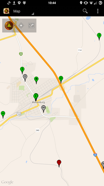
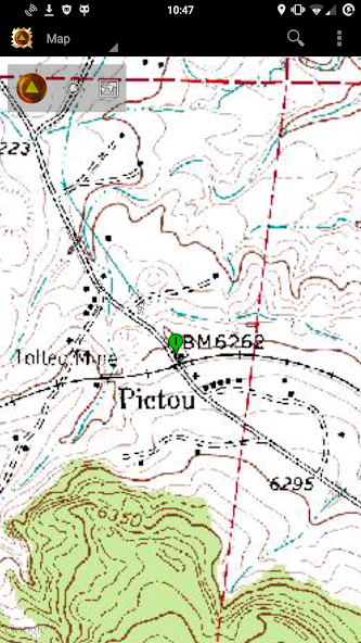
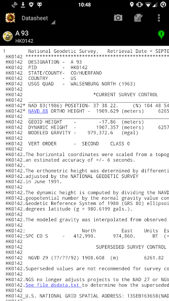
BenchMap allows searching and viewing of National Geodetic Survey (NGS) survey stations on an interactive map. The map will allow you to quickly determine if the control station is usable, and whether the chances that it still exists. Once a station is selected, you can view its datasheet - both in the app and through your web browser. You can also pull up the Geocaching page, in case there may be useful notes that aren't on the NGS's site.

Tools for submitting a recovery to the NGS inslude allowing you to take pictures of the station (using the recommended naming format), and record notes. (At this time, submission of recoveries is not possible in the app - but may be available in the future!)

Filtering allows you view just the types of stations to display that you want - like certain stabilities, horizontal/vertical orders, and destroyed/non-publishable status. You can also directly search for a PID and have the map take you to the location of the station.

Made for the professional surveyor and the hobbyist out there in the wild.

Note that the application will only display NGS survey marks. At this time, certain agencies' stations will not appear in the app, unless their survey controls were submitted to the NGS. These agencies include:

- United States Geological Survey (USGS) - they will never digitize their station database.

- Army Corps of Engineers (ACE) - they have an online database, but at this time no API to pull data from.

- Department of Interior (DOI) - Stations for the DOI that don't fall under the ones above at this time have no API.

If any of these open up an API to pull survey marks from, they will be included.

What's New in the Latest Version 2.5.2

Last updated on Feb 4, 2021 Includes small fixes:
- Less battery usage when app is not in foreground.
- Fix to some user's 'My Location' dot not showing up.
- Adds bearing arrow to dot when moving.
- Updated linked libraries.
Download(2.45MB)
Users also viewed
  • Gett

    Gett

    10.35.80 December 1, 2025
  • Thailand Navigation

    Thailand Navigation

    1.0 December 1, 2025
  • 247 Radio Cars

    247 Radio Cars

    8.0.1 November 30, 2025
  • Jet Lag Begone

    Jet Lag Begone

    1.0.5 November 30, 2025
  • My BUS chennai(MTC)

    My BUS chennai(MTC)

    2.01 November 30, 2025
  • KCTV5 On Time Traffic

    KCTV5 On Time Traffic

    3.4.0 November 30, 2025
  • UrWay

    UrWay

    1.5 November 29, 2025
  • GetAFix

    GetAFix

    15.5 November 29, 2025
  • DevSul FIPE

    DevSul FIPE

    1.0.19 November 29, 2025
  • Malaysia Travel

    Malaysia Travel

    1.10 November 29, 2025
  • Book Hotel - Best Hotel Online

    Book Hotel - Best Hotel Online

    1.06 November 29, 2025
  • Solaris FAQ

    Solaris FAQ

    0.1.5 November 29, 2025
  • 100 Fronteiras - Passageiro

    100 Fronteiras - Passageiro

    18.21 November 27, 2025
  • MobileMeter

    MobileMeter

    9.2.17 November 27, 2025
  • DLT GPS

    DLT GPS

    2.0.11 November 27, 2025
About Privacy Policy Terms of Service Cooking Policy

© Copyright 2017-2025 downzq.com