
Topo maps & aerial maps to plan hiking trips, outdoor & camping adventures
Explore like never before. MyTopo Maps is a mapping and trip planning app to organize all your outdoor and backroad adventures.
View more than 68,000 topo maps in US and Canada. Also, check out aerial, terrain, street and hybrid maps. Mark points, find places and store all your trip info on the Trip Cloud, a wireless service that allows you to access your trips on any device.
*** Note: This app is designed for the Android tablets. Got an Android phone? Try Trimble Outdoors Navigator, our in-the-field navigation app. ***
Aplikasi ini adalah yang terbaik untuk: jalur kepanduan, menjelajahi taman, merencanakan liburan di luar ruangan, melihat area pedalaman di peta topo dan foto udara, menemukan jalan hutan dan tempat perkemahan, jalur hiking preplaning, rute sepatu salju, sesi ski pedalaman, berkemah dan perjalanan offroad ATV di ATV, ATV Tripss, ATV Snoadshoad Trip
------
** START WITH A GREAT MAP **
• View five different map types: streets, hybrid, aerial, topo and terrain.
• MyTopo Maps provides the most up-to-date topos maps available in the United States. We have enhanced more than 14,000 USGS quads with digital updates from the US Forest Service and other map providers.
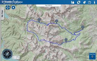
• Access more than 68,000 topo maps in US and Canada that are seamlessly stitched together for fast and easy viewing. Topos scales are 1:24K in the Lower 48, 1:63K in Alaska and 1:50K in Canada.
• See two maps at once. No single map type has all the essential details to plan a trip. So turn on Dual Map View and fade between two different map types.
• View aerial imagery from Bing maps.
• Upgrade to Pro to create map packs to store maps on your phone. This app allows you to save topos (MyTopo), aerials (Bing), streets (OSM), and terrain (OCM) map types on your phone.
** POWERFUL TRIP PLANNING TOOLS **
Place Search: Use our search to find more than 10 million places. Trails, peaks, lakes, rivers, ghost towns and more.
Ruler: Measure the distance between two points.
Smart Paste: Copy GPS coordinates from websites and instantly map their locations into MyTopo Maps .
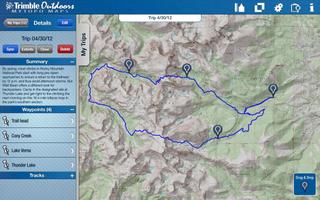
Waypoints: Drag waypoints on to the map. Name them and add descriptions.
Coordinates: Match your latitude/longitude or UTM coordinates to your paper map or GPS device. Supported map datum: WGS84 and NAD27.
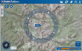
Digital Compass: Press the mini-compass to overlay a large digital compass on the map.
Custom Paper Map: Order a waterproof custom printed topo map or aerial image directly through our app with just a few taps of a button. Printed and shipped by MyTopo.com within 24 hours.
** SAVE TO THE TRIP CLOUD **
Register a free account to save your outdoor trips to our Trip Cloud. Manfaat termasuk:
• Store and backup unlimited trips. Never lose files again.
• Auto-sync trips between your computer, mobile phone and your Android tablet.
• Meningkatkan perjalanan yang direncanakan di MyTopo Maps dengan lebih banyak alat peta di TrimbleOutdoors.com, termasuk impor .gpx, foto dan video geotag, rute turn-by-turn dan banyak lagi. (requires membership)
• Open trips in our mobile navigation app, Trimble Outdoors Navigator. Learn more: http://get.it/trimbleoutdoors/8oUv
• Share trips with the Trimble Outdoors community or privately between outdoor friends.
** LEARN MORE **
Visit our website and check out thousands of trips submitted by the Trimble Outdoors community. Click over to: trimbleoutdoors.com.
-----
Note: This version of MyTopo Maps is designed and optimized for Android tablets. Please note your device must have a GPS chip to show your exact location on a map. Penggunaan GPS yang terus berjalan di latar belakang dapat secara dramatis mengurangi masa pakai baterai.
 unduh
unduh